

Mega-Streams of the Atlantic
Where are they hiding?
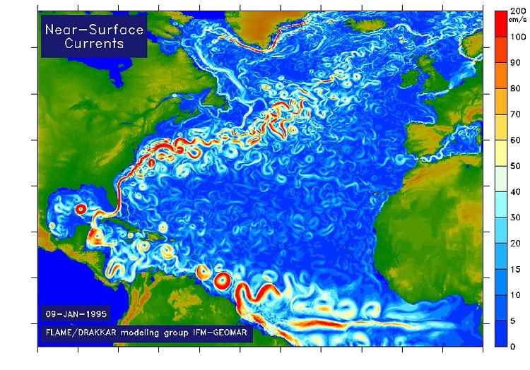
In the middle of the Ocean, between Greenland and Norway and before Newfoundland, enormous masses of water disappear from the surface and plunge straight down to the bottom – thousands of meters deep, according to scientists. Like the drain-hole of a bathtub, this succion movement draws twenty times more water into the abyss than all the rivers of Earth together carry into the oceans.
This downward motion is the engine which from all appareances powers the whole global conveyer belt, the mighty system of water exchanges between the seas and oceans of Earth. The Gulfstream participates prominently in this so-called thermohaline circulation: in tropical regions, the sun heats up the surface waters and through evaporation, it increases the level of salinity. Additionally propulsed by winds and deviated by means of the Coriolis force created by the Earth’s rotation, the Gulfstream transports water from the Equator to the North.
But where are the mega-streams hiding?
The Gulfstream and its northern offshoots constitute a decisive factor in the European climate: without the heat energy of the Sea, which is equivalent to the output of half-a-million large nuclear plants, climatic conditions in Europe would be equivalent to Siberia’s. When the water adducted from the tropics cools down at last, it acquires denseness again, sinks into the deep and flows back South. In the long term, this mechanism also presides over warm periods and ice ages.
The theory seems secure – and forecasts about the Gulfstream and about the climate are based on them. There is only one hitch: nobody has ever observed the gigantic downward currents.
"Where and how the water sinks down, we do not know,” says oceanographer Jochem Marotzke, Director at the Max-Planck Institute for Meteorology. Despite the fact that scientific research vessels have been cruising the area for almost one hundred years, and that they have studied the ocean all the way to the bottom, and are constantly watching measurement buoys in the waters, scientists have been merely able to identifiy tiny downward swirls.
In the Sea of Labrador and in front of Greenland alone, 150 times more water is supposed to sink to the bottom than is driven into the ocean by the Amazon. But merely trickles have been found. The vertical twirls are “small and therefore not directly measurable,” says Detlef Stammer, an oceanographer from Hamburg. “It’s a challenge, to have a measuring instrument at the ready in the right spot and at the right time.” The search is made more difficult because the water apparently sinks only sporadically, and the areas of down-welling move around, explains Stammer’s colleague Detlef Quadfasel.
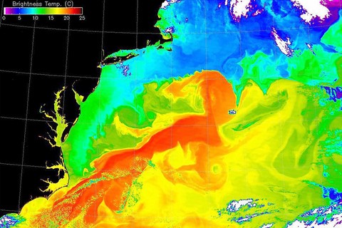
A satellite picture of the Atlantic before North America in May 2001: the colors symbolize the repartition of temperatures on the surface of the water. In the red areas, it reaches up to 25° C.
Hunting with sonar-probes
Researchers put themselves downright on the qui vive – so for instance on the German research boat Maria S. Merian: they let probes down into the sea, which send out sound waves and register their echo. Sinking water makes the sound waves expand – like the sound of sirens changes, when a police car passes by quickly.
The instruments carry out a measurement every ten minutes; after three years at most, they are retrieved. From time to time, the instruments manage to register tiny swirls of sinking water: funnels a few hundred meter broad where single swirls drip down at a speed of a few centimeters a second. Plancton is sucked down along into the depths, there is no danger for larger living beings or for boats, Quadfasel says. “But these are indications which we are merely deducing from a few measurements.”
Yet in order to power the Gulfstream, according to the accepted theory, mighty masses of water must be sinking. That this is actually happening is proven by the traces left by atom bombs: nuclear tests in the fiftieth and sixtieth have left their traces in the oceans, radioctive tritium having trickled onto the surface of the seas.
The Gulfstream carried these isotopes North; there, researchers verified their presence years later at over 3000 meters depth. At the beginning of the eighties, underwater streams had conveyed the traces of the atom bombs all the way back to the southern hemisphere. These fluxes in the seas confirmed the theory of the world-girdling oceanic circulation.
Freshwater endangers the sensitive system
Oceanographer Wallace Broeker recognized early that the circulation must be susceptible to disturbances. A difference of only a few per thousand in salinity decided over the fact whether Europe’s heating system would function properly: if too much rain or meltwater thinned the Atlantic, the water would lack the weight necessary to make it sink; as a consequence, the succion movement would come to be disrupted.
In 2005, it seemed that the theory was turning into reality: the Gulfstream started carrying one third less water towards North, British scientists warned in the magazine Nature. They were basing themselves on the data from five boat expeditions between 1957 and 2004, in which fluxes on the surface had been measured around the Canary Islands.
It was a false alarm: chance had it that the scientists took measurements at unfavourable moments. Verifications showed that the masses of water driving towards North can vary widely – at the end of one week, they can be nine times as large than they were at the week’s beginning. Many oceanographers wondered over the fact that Nature had published the paper in the first place. The soundness of the alarm could have been verified with data from the deep seas. “They could at least have given us a phone-call,” says an oceanographer from Kiel.
When Studies don't match reality
This incident shows how sketchy the knowledge really is. However, oceanographers noticed in 2007 again a halt in the Gulfstream. Over eight years, almost no water had gone down in the Sea of Labrador facing Newfoundland – one of the two outlet gullies of the warm Northstream was paralyzed.
This warning too was based solely on indirect measurements: temperatures and degrees of salinity at different levels had adjusted to each other, so that many scientists believed in a stagnancy of the flow. A dramatic scenario seemed to be possible: the progressive warming could increase the thawing of the glaciers of Greenland and their meltwater could disable the sinking flow beyond recall.
But the opposite happened: indeed in the very winter of 2007/2008, when the weather let one expect a totally different evolution, the Gulfstream engine in front of Newfoundland kicked into action again. Scientists verified that the watermasses in the sea of Labrador had been mixed down to a depth of 2000 meters. “Many of the things we take for granted about our oceans will have to be re-eaxamined,” concluded Susan Lozier of Duke University in Durham (North Carolina).
Yet already during the eight years during which the Gulfstream had come to stall, some scientists had aired doubt. Along the sea bottom, the stream had continued southwards with undiminished force, says Martin Visbeck of the Leibniz-Institute for Oceanic Science in Kiel. In order to keep the circulation going, massive amounts of water must therefore have sunk to the depth. Only: where this happened remains unknown to this day.
Axel Bojanowski,
Original article: Der Spiegel, July 24, 2009
(Translated from the German by Anne-Marie de Grazia)