The "Great Plain" of Atlantis - was it in Doggerland?
The Atlantis of Jean Deruelle
The "true heart of Europe"
It was inevitable that Doggerland (See: Doggerland lost), the part of the North Sea which was left dry for several thousand years after the end of the last ice age, should come to be considered as one more possible location for Plato's Atlantis. Doggerland stretched all the way from the east coast of England and Scotland to Denmark and supported a thriving mesolithic population. "It was the true heart of Europe," says Richard Bates, geochemist at St Andrews University in Scotland. It struggled for several millennia against the rising sea levels, then was submerged in a sudden catastrophe at a date estimated between 6200 B.C. and 5500 B.C. (Maybe caused by, or connected to the Störegga Landslide). Robert Graves himself had briefly considered the area of shallows known as Dogger Bank as a possible location for Atlantis, before dismissing it on grounds of distance.
As it happens, more than a decade before geologists focused attention on Doggerland at a 2012 meeting of the British Royal Society, a Frenchman, Jean Deruelle, had published a book making a strongly argumented case for the notoriously elusive "Great Plain" of Atlantis having been situated on now submerged land in the North Sea. He published his hypotheses in 1999, in a book called "L'Atlantide des Mégalithes," as part of a broader examination of the spread of megalithic cultures and little studied West to East movements of populations. The book was published by a reputable publisher of historic books, but received scant attention.
Jean Deruelle was born in 1915 in Longueville (Nord) and studied at the elite French Ecole Polytechnique. He was the CEO of the French coal mining company, "Les Houillères de Lorraine." During his retirement, he indulged his life-long passion for Brittany and the megalithic civilizations of Europe. He died two years after the publication of "L'Atlantide des Mégalithes."
The location of the "Great Plain" has always been one of the biggest stumbling blocks for any Atlantis identification. Deruelle, an engineer and a geologist by profession, offers a hypothesis that is rational, highly precise, and based on his areas of expertise. No other hypothesis than Deruelle's tackles so credibly the most outlandish elements in Plato's description of Atlantis: the description of a vast plain, surrounded by a man-made ditch, 180 meters broad and thirty meters deep, large enough to circulate supertankers: it was not a ditch, but a dyke, build over centuries to protect a large part of Doggerland against the slowly rising waters of the North Sea... As for the literary form of his book, he chose a lighthearted approach, keeping to a semi-fictional threat of a wide-eyed, naive amateur, a character by the name of Thomas, who is learning as he goes along, and reporting to a chorus of bemused and sceptical relatives and friends.
When he is finally ready to sum up for them his new theory of Atlantis, he gathers them in his home in Platonic fashion, for a "Symposium," or a traditional French dinner.
We surmise that the reader is well informed of Plato's story of Atlantis and of its problems. All those who do not dismiss Plato's tale of Atlantis as a mere backdrop for politic-fiction, devoid of grounding in reality, know that there is a fundamental contradiction: because he presents the Atlanteans as engaged in a war of aggression against Athens and Egypt, one must chose either to follow the dating of the event as reported by Plato, who situates the catastrophic end of Atlantis around 9700 B.C., but then one must give up the idea of a war with Athens and Egypt as fiction, as neither of these powers existed at the time; or one choses to follow him on the legendary-historical war story but then, one must dismiss his dates.
Deruelle, who needs to have his Atlantis contemporaneous with the great megalithic civilizations, choses the dates of 7000 BC and 2600 BC for its beginning and its end. Earlier dates might have suited his thesis better, as the drowning of Doggerland is dated some 2500 years earlier, but this late date gives him an opportunity for interesting conjectures about the respective evolutions of the oceans levels and of the ground levels in this area of the North Sea over the past 20,000 years.
That astonishingly advanced civilizations can have existed elsewhere at the time which Plato (or the Egyptian priests who are his source) indicates for Atlantis, is being proven right now by the archaeological digs at Göbekli Tepe in Turkey, should their dating at 9200 BC indeed hold. But these, which have left the archaeological world dumbfounded, have come to our knowledge only recently, and Deruelle would surely have been enthusiastic, had he lived to hear about them.
Now, to make straight the aspect and dimensions of the "Great Plain," which we are referring to, according to Plato:
this plain had a level surface and was as a whole rectangular in shape, being 3000 stades (530 km = 330 miles) long on either side and 2000 stades (360 km = 225 miles) wide at its center, reckoning upwards from the sea. And this region, [Critias - 118b] all along the island, faced towards the South and was sheltered from the Northern blasts. And the mountains which surrounded it were at that time celebrated as surpassing all that now exist in number, magnitude and beauty; for they had upon them many rich villages of country folk, and streams and lakes and meadows which furnished ample nutriment to all the animals both tame and wild, and timber of various sizes and descriptions, abundantly sufficient for the needs of all and every craft. [Critias - 118c] Now as a result of natural forces, together with the labors of many kings which extended over many ages, the condition of the plain was this. It was originally a quadrangle, rectilinear for the most part, and elongated; and what it lacked of this shape they made right by means of a trench dug round about it. Now, as regards the depth of this trench and its breadth and length, it seems incredible that it should be so large as the account states, considering that it was made by hand, and in addition to all the other operations, but none the less we must report what we heard: it was dug out to the depth of a plethrum (ca. 30 m = almost exactly 100 feet) and to a uniform breadth of a stade (180 m = 196 yards), and since it was dug round the whole plain [Critias - 118d] its consequent length was 10,000 stades (1800 kilometers = 1120 miles).
If the dimensions of the Plain must appear awesome, nobody in his right mind can believe the veracity of these later numbers, relating to a man-made ditch! These are so far "off the chart" that they understandably undermine the credibility of all the other indications. Only Deruelle - or his alter ego Thomas - succeeds, at least, in making sense of them.
In front of his guests, gathered for apéritif, Thomas unfolds a map. The first task is to find a rectangle of 530 km by 360 km which could have stayed out of water until around 2600 BC.
Here is what north-western Europe looked like in 18,000 BC, at the end of an ice age which had lasted 70,000 years. You see, the doted line shows the present coastlines. The areas covered by the sea are in grey. The formation of ice at the expense of the oceans brought down the sea level by 120m.
We can see that the sea is 100 km to 150 km away from the present coastline of Brittany and Ireland. The English Channel and the Irish Sea were dry, but space is lacking there for our Great Plain. On the other hand, we find that the North Sea is dry all the way to the latitude of Scotland, 800km from the Netherlands, on a breadth of 500km separating England from Denmark.
A friend exclaims about the extreme flatness of this uncovered land:
"That's hardly believable! A one hundred meter rise can be swallowed in two minutes by car, and here, one would have to cover 800 km!"
"Unbelievable, indeed! All the way from the Netherlands, the ground rises only by a hand's breadth every kilometer! This is an exceptional 'geological case!' But it responds admirably to Plato's description of a Great Plain ‘flat and of a uniform level.'"
"No wonder man would have settled in such a vast territory!"
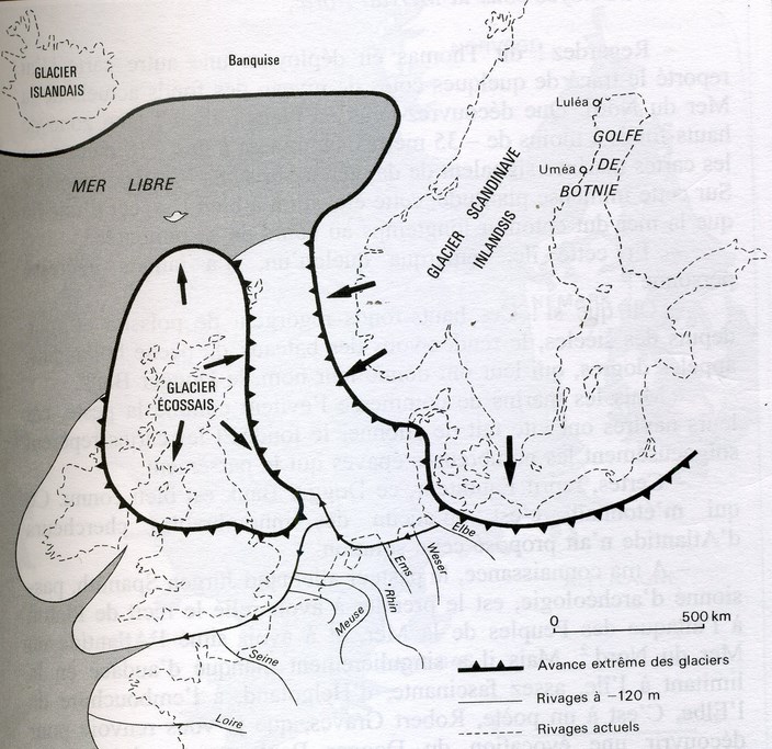
Northern Europe around 18,000 BC. The polar ice sheet was crushing Scandinavia, reaching Denmark and part of the North Sea, which had dried up all the way to the Orkney Islands, because of the 120 meter drop in sea level. The Scottish glacier covered the west of the North Sea. The retreating of the water pushed the Atlantic back 150 km from the present shores of Brittany.
The area was not very hospitable then! The map shows the extreme advance of the ice-sheets, well known from on-land, but less so under the sea. An enormous glacier two to three thousand meters thick covered the mountains of Norway and advanced on the North Sea. It's moraine formed the backbone of Denmark. Another glacier, less huge, crowned the mountains of Scotland and occupied the West of this area. It's only when the climate warmed up considerably in 10,000 BC that the area became inhabitable.
Moreover, there exists in this area a submerged island, namely the Dogger Bank.
Thomas unfolds another map, showing the level curves of the bottoms of the North Sea. They show an area of shallows of less than -35m, culminating at less than -18m, where marine maps signal dangerous breakers during storms. In the middle of the immense platitude of the plain, this elevation looks indeed like an island which the sea no doubt surrounded for a long time as it kept rising.
"These shallows are replete with fish and have been for centuries the rendez-vous of dutch fishing boats, called doggers, which gave it its name, the Dogger Bank."
How did this outcrop come to exist? The bottom of the North Sea has been planed by several ice ages in succession. The western face of the Dogger Bank is probably a moraine pushed there by the Scottish glacier. It has been deeply ravined by the movements of the water, which were forced to find their way around it. There are cliffs there, with a vertical drop from -20m to -40m. The north face is less abrupt but the ground still goes down quickly from -35m to -60 m.
This conforms to Plato's saying that the Plain dominated the sea by a vertical drop, and that on the other side of the drop, the Plain went down in a gentle slope, which is what we can make out. The Dogger Bank is prolonged, to the north-east, by elevations at -40m in the direction of the coast of Denmark.
Over drinks, the guests make two remarks: on the one hand, with its 300km on 100km, Dogger Bank was far from reaching the dimensions of the Great Plain of Plato. And then, one had to make sure that it was still out of water at the time of Atlantis, between 7000 B.C. and 3000 B.C.
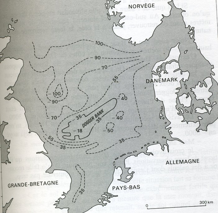
The present North Sea bottom. Over 800 km, the ground slopes only 10cm per kilometer. In the middle, at -50m, there is a low rise, 20 m to 30 m high, 150 km long, 60 km broad, the Dogger Bank, which creates a hazard zone for navigation.
The opinions of the specialists on this matter, Thomas admit, have been utterly discouraging: they say that the Bank was already submerged by 6000 BC.
"Well, then..."
But I believe that I have found a flaw in the conclusions they draw from their observations. In order to make myself more clear, I had to resort to some calculations which I hope will not put you off too much...
The rise of sea levels since the last ice age, explains Thomas, has been of course of the utmost importance to Dutch geologists, their country having been conquered on the sea, and its defense against rising sea levels has been a continuous struggle. But this situation has made its fortune!
Because the soil is made of an extremely fertile peat, which formed itself slowly in fresh water marshes where it was held back, on a soil of a naturally feeble slope, behind a string of costal dunes, while the sea was rising. Radiacarbon dating has found of date of 6600 BC for the peat found at -19m, where it makes contact with the natural soil at the vertical of the coast, from which geologists have deduced that it was at that moment and at that level that the sea had reached the coast of Holland. All that would have emerged at that time of the Dogger Bank would have been an islet above the -19m line. Since then, and ever more slowly, the regular rise of the sea level has thickened the peat layer to its present level.
"That's bad, my dear Thomas! That's very bad for your Atlantis!"
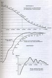
Except that... continues Thomas, who has more charts at hand. There are curves which give the average of measures obtained by diverses techniques on all the oceans of the globe. They give an account of the general variation of the levels of the seas, called "eustatics." The inferior part shows (curve in full line) how the level of the oceans has gone up by 100 m since 14,000 BC.
You will notice that it is around 6000 BC, and not today, that the present level has been attained. The blown-up graphic below shows that this level was exceeded by 3m to 4m during the warm period of ca 4000 BC. Then we witness a series of oscillations, the dates of which are still not well known, but which tend generally to slow down.
Which doesn't mean that the Dutch scientists are wrong. It just happens that the same words don't always mean the same things. The Dutch, like most regional researchers, talk only about what they are able to measure: the variation of the present level of successive shorelines, the traces of which one can find in the soil at different periods.
But the level of the shorelines is different from the rise of the sea levels because, in any given point, the shoreline rises if the sea rises, but also when the ground subsides! And as it is difficult to measure the movements of the ground, there is a tendancy to consider them as negligible and to treat the shoreline curves as if they merged neatly with eustatics. There's a flaw there, says Thomas, which I deemed legitimate to explore.
"Let's see, says a guest. If the sea has reached its present level in 6000 BC, and if the Dutch find their coastline at -19m at that date, it means that their land has subsided by 19 meters!"
Geologists have been intrigued to find on several hundreds of meters on the flanks of Scandinavian mountains the traces of succesive shorelines. They conclude from it that the earth's crust has subsided by some 300m in the North of Sweden, under the enormous weight of nearly 3,000 meters of ice, hollowing out a kind of a bowl, the lips of which found back to the level zero near the limit of the glaciers. Beyond this "neutral line," the repressed magma had formed a "compensatory bulge" which elevated the earth's crust. Since 18,000 BC, the melting of the ice has had a reverse effect, the ground is going up in Scandinavia and down at the place of the bulge.
This going back to normal is not finished yet. Maps show the residual movements of the soil at the present time.
In Scandinavia, the curves of equal rise turn around the bottom of the "bowl" which is well marked in the North of the Gulf of Botnia. The ground goes up there by some 9mm/y. The rate diminishes as one moves away from it. The neutral line, with zero movement, cuts through the North of Denmark.
Beyond this neutral line, begin the residual subsidings of 1 to 2millimeter/y, even reaching 3mm at the mouth of the river Elbe. They draw the contours of the "bulge" which compensated for the subsiding of the bowl.
A 1mm/y subsidence may seem negligible, but it would add up to 8 meters in 8,000 years. And this is only one residual movement among the most important. Here's another place where a fault may have found its way into the reasoning of the scientists.
"So you've tried to reconstruct the state of the ground in 8000 BC?"
And even earlier, in 18,000 BC, when we know that the 300m subsidence of the Gulf of Botnia occurred. Let's look at this map which blows up the North Sea section. It shows the "official" curves, which stop neatly when reaching the coast, because scientists hesitate to guess what goes on under the sea, where they cannot rely on measures.
I took the risk of prolonging them as logically as possible. I hope that you will find the result elegant, at the least!
They are all impressed. One can see the lip of the Scandinavian bowl along the coast of Norway but also, in the west, the bowl of the Scottish glacier, which is still rising 3mm/y. One finds the neutral curves at 0, and then in the axis of the North Sea, the compensating bulge which subsides by 2mm to 3mm/y.
The North Sea bottom must then have been considerably higher than today!
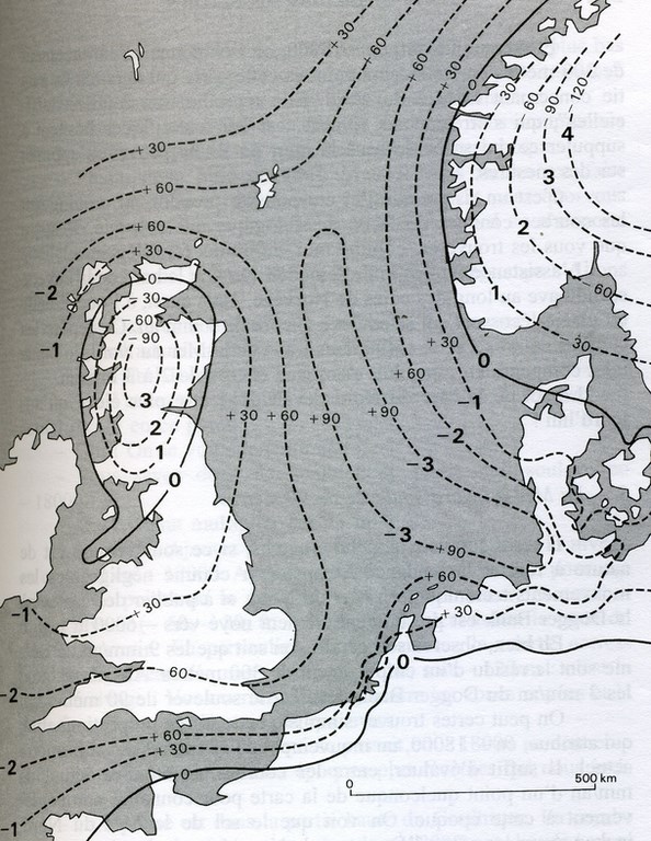
The rise of the North Sea - The weight of the ice sheet had pushed down the soil in Norway and Scotland. A compensating bulge had formed between them. The melting induced opposite movements. The dotted line shows the rises (+) or drops (-) which are still to be made out along the shores. Their prolongation beneath the sea gives the outline of the "bulge" which lifted the soil. We indicate on these lines, between Scotland and Norway, an estimate of rises reached in 18,000 BC.
"Well, remarks his son in law, we know that the 9mm/y of the Gulf of Botnia are the residual movement of a 300m subsiding. At the same rate, the 3mm/y of the Dogger Bank should have lifted it up by 90m!"
One may find simplistic this law of proportionality, which attributes, since 18,000BC, a total movement of 33m, of which 1mm/y are occurring at the present time. It suffices to evaluate between the curves, the present number of mm/y of any point of the map, to know its rise at that time. We see that the ground of the North Sea, unchanged on the coast of Scotland and Norway, rose slowly to reach a level of 60m to the West of Dogger Bank and 90m to the east. It's considerable, and whatever the degree of uncertainty of the calculation, it's far from being negligible.
"Unfortunately, under the sea, nothing can be verified!"
Maybe that geology is giving us a hint by declaring to be "unexplainable," off the coast of Scotland, some north-south oriented ravines dropping to -200m, that is, 80m lower than where the sea was! Nothing surprising to that, if the soil was lifted up by that much. Rivers have dug their estuaries there.
You know enough to be able the draw the map of the North Sea in any year since 18,000 BC! To begin with, it is easy to find the reading of the present level of the sea bottom at any point of the map, by using a marine chart!
You now can also evaluate the number of mm/y of the present movement of the ground in this point by checking it on my map. The curve shows how the 33m per m/y of 18,000 BC have diminished through the years. For any date, you will find the residual rise, and, vertically below, the level of the seas. The math-heads among you will be able to verify how it works.
"Alright," mumbled a math-head. "But where do you get your negative growth curve from?"
Well, the geologists would have all elements at hand to establish it! Lacking it myself, I had to invent it! We know that changes have been very slow at the beginning. Between 18,000 BC and 14,000 BC, the "33m" would have gone down only little. We must also arrive at the present date with a slope of 1mm/y. Between the two... the measurements from Holland give me a rise of 16.5m in 6,600 BC (19m minus 2.5m of sea levels).
The guest go to dinner. When they return to the salon, a new map is shown.
On these bases, this is how the north-west of Europe presented itself in 7,000 BC., at a time when, according to Plato, "neither ships nor sailing were as yet in existence," (Critias 113e) and when Poseidon decided to protect his beautiful Clito from the sea and divided his land among their ten sons.
You see that the sea, in grey, 5m below its present level, licked the slopes of the Dogger Bank which dominated it by some 15m. [We might point out that it was probably more, on account of the erosion having occurred since.] Men, who had been moving back for a thousand years on a hopelessly flat terrain, found refuge on this mountain "of a mediocre altitude" but the sea began to encircle it by the north-east, where an outcropping was already almost isolated.
To the south-west, the sea infiltrated more deeply, penetrating in deep ravines which had been dug by the rivers forced to circumvent the Bank. To the south-east, the terrain found back to the weak slope of the natural soil.
Thomas' level curves bring to the fore some striking pecularities: in the direction of the mouth of the Elbe, the ground reaches a reading of +10, then of +14, to reach a vast outcropping at reading +30m, encompassing the whole valley of the nether Elbe. Beyond, it slopes down rapidly to the present level of the land. He concludes that the "bulge" which had been brought about by the ice-age had forced the Elbe and the Weser to divert their course to the West, probably in the direction of the Zuydersee... Where another surprise is in store: the map of the mm/y movements shows that the bulge prolonged itself towards the Pas-de-Calais. The +14 curve shows that there subsisted, along the Belgian coast, a "glove finger," which narrowed the access to the English Channel. But above all, this dam protected, in the east, a vast bowl formed, from the Schelde to the Zuydersee, by the natural soil which the thick layer of peat had not yet covered!
All these waters formed a huge swamp the exit of which, situated near Texel, the first of the Frisian islands, directed their flow towards the deep ravines observed at the south-west of the Bank, towards the channel of the Pas-de-Calais.
Thomas admitted that the geologists to whom he had submitted his idea had not rushed to congratulate him. Neither could they find fault with his reasoning.
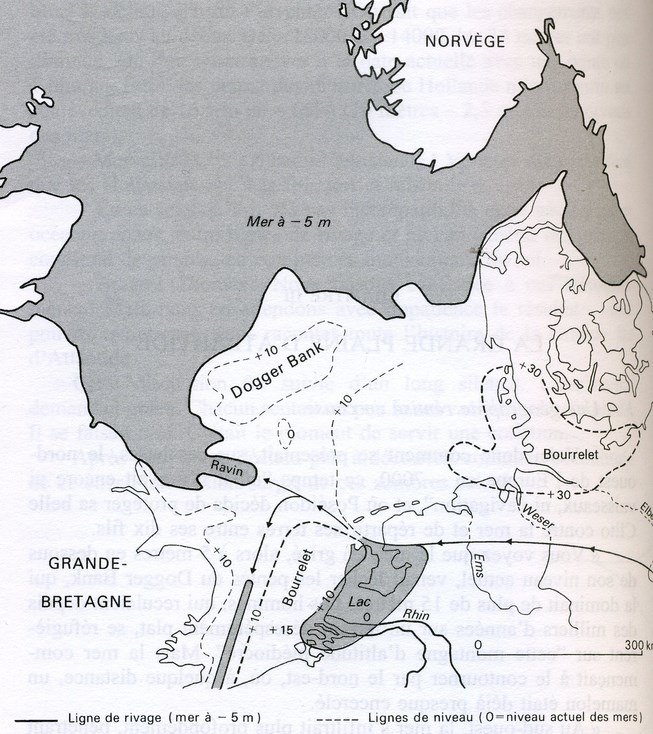
The North Sea in -7000 BC. The Dogger Bank begins to be surrounded by the sea. Level +30 deviates the rivers Elbe, Weser and Ems towards a lake held in by level +14 in the Netherlands. The effluent digs the Silver Pit to the west of the Dogger Bank and, to the south, the ravine towards the Pas-de-Calais.
Now look at this map and decide what you would have done if you had lived in this country, ever more eaten up by the sea.
"The solution is known: build dykes!"
"But this would have been quite beyond the capacity of these isolated and unorganised tribes! They could only keep fleeing from the advancing sea..."
...and abandon the tombs of their dead, which for thousands of years, they had protected with the help of indestructible megaliths and barrows? But they had also organized themselves early in order to reinforce the dunes of the coast with embankments. All this would explain the discipline, the emergence of a sense of the common good and the taste for vast public works which one can surmise to have characterized the civilization of the megaliths, explains Thomas, waxing enthusiastic.
These people were accustomed to defending their territory. And the circumstances were particularly favorable! The Dogger Bank offered a natural bareer 15m high (or more...) and 300km long! It sufficed to reinforce it on its flanks.
Imagine the situation. A tribal chief, let's call him Atlas, has put up his hut at the highest point of the Dogger Bank, on top of a vertical cliff, from where he could survey the surroundings. He called on his neighbors: let's stop dispersing our strengths! You see there this enormous river which comes straight towards us to throw itself at our feet in this ravine through which the sea progresses? It suffices to erect, on our side of the river, an embankment, in order to protect in due time the whole plain which is behind. But all the tribes would have to send me a contingent of workers!
They all agreed that he was right, and that the realisation was not particularly difficult. An embankment of 3 meters would have brought protection for one hundred years. But there was a worse danger to avert. "I have explored this mountain until its tip, very far to the north. There too, the sea is beginning to infiltrate the plain through some kind of a valley, beyond which one can see, in the distance, a line of some elevations, which could also protect us. We should build there a big dam, which looks possible to me because, interestingly, there is no river in this valley! I suggest therefore to send a delegation to the tribes in the north so that they associate themselves in a solemn pact for the defense of our Plain!"
The pact was made. The chief got powers to bring to completion his program on the whole territory. They agreed that they would have to get into the good graces of the god of the sea, whose assaults would have to be brought under control. They would build for him a temple at the highest point, where a collegium of priests would honor him and try to figure out his intentions in order to provide guidance for the work to be done.
And that's how, concluded Thomas, in 7000 BC, a tremendous struggle might have been engaged in order to counter the rise of the waters!
And how an enterprising tribal chief was able to extend his authority over the vast lands of the megaliths.
To the South of the Dogger Bank, the battle-plan was laid out by the terrain itself. It sufficed to shore up the bank of the river, which was almost rectinilear, flowing on a very flat surface. As the sea rose, it had to be elevated, and prolonged towards the coast of Holland.
To the north, it was much more difficult to cut through the valley, an ancient bed of the diverted river Elbe. The dam was exposed to the terrible storms of the North Sea and would have to be prolonged by and by over 50 km.
Beyond, left-over moraines would have offered protection in the direction of the east; but the sea already infiltrated there through numerous ravines. So they decided to put their line of defense further back, on the flat land, which, to the south-east, rose gradually in the direction of Denmark.
The map of 7000 BC shows the line of these first dykes. And the result to which, guided by the configuration of the land and the evolution of climate and terrain, might have lead, by 3,000 BC, four thousand years later, a faitful continuation of these politics.
The Dogger Bank and its three dykes, in full lines, prevented the sea from invading this immense territory which extended all the way to today's coasts. Now, is this not a space which can pretend to the title of a "Great Plain"?
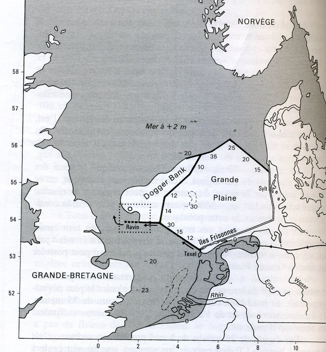
Taking a hold on the still emerged Dogger Bank, the Great Plain is spreading at 10 or 20 meters below sea-level, protected by mighty dykes. The continental waters are stopped by the shoring up of the Frisian and Danish islands. Behind this dam, the sea penetrates on the low-lands presently covered by a thick layer of peat. The ground of Denmark has not yet sunk back enough to allow the Elbe to find back to its bed.
I have calculated to which height , including a 5 meter keep, these works had to be raised. The most dramatic point was of course to the north, with a maximum of 35m, the crossing of the old Elbe bed. But between 20 and 30 meters would have sufficed in most points.
Dykes thirty meters high! protested someone. But this is enormous! Because one must calculate, at the summit, a breadth that is equal to the height! That would hold an autoroute! And then at the base, there's a rule of thumb, you need six times more, that's 180 meters! And all this on a length of 1000 kilometers, you must admit, it's hard to believe!"
"‘Hard to believe,'" indeed, that's exactly the expression employed by Plato.
Let's do as he does: let's pursue our calculations. At the most critical moment, around 5000 BC, when the sea is rising by 7m per millenium, one needs adding only 1.2 centimeter to the dykes every year in order to keep up with the rise of the waters, that's about 1 to 4 cubic meters of dirt per kilometer per day depending on the height. We must take into account the utter slowness of the process and the millennia at disposal.
Run-off waters and rivers would have been a major problem in such a huge area situated below sea-level. Long before 8000 BC, the "bulge" had diverted the Elbe and Weser rivers towards the great lake of the Netherlands, where they joined up with the Rhine. All these waters were evacuated near Texel, forming now a great river with firm banks. The Great Plain was rid of them!
By 3000 BC, the situation had become very different, as seen on the map. The sea had come closer to the exit of the lake, which the subsidence of the ground had made broader. The "great river" itself having been drowned, the soil became propitious to the formation of peat.
Forgive my vanity for finding here a confirmation of my theory of the "bulge!" It is the bulge which dammed the lake where the peat deposited. That's why one can't find any peat anywhere a few kilometers from the present coast, or anywhere at the bottom of the north sea!"
"Do geologists ignore the existence of this bulge?
They don't venture to look beneath the sea, where the absence of peat does not intrigue them! But they are perplexed by the formation of the Frisian islands, which follow the coast of Groningen from Texel, near the Zuydersee, all the way to the mouth of the Elbe. Practically at sea level, they protect a swamp which is filling up with peat. How could these islands have come about? They are a residue of the bulge, which became thicker towards the north and which has not yet been submerged.
As for the Atlantis people, it would have been enough for them, by taking a hold on Texel, to watch and reinforce if needed the natural dyke formed by this bulge. The map shows, in 3,000BC, the deep penetration of the sea behind this dam, like a slender finger. It is probably through this exit that the river waters, still prevented from gaining back to their old beds, flowed out.
Thomas believed that the same tactic had been employed by shoring up the dykes on the low islands along the Danish coast, until joining up with the mighty works coming from the north-west. The Great Plain was in such a way protected from the sea, but also from the water of the rivers.
" But the rainwaters, how did they run off?" asks his daughter.
What do you do with the water, indeed, in a region where it rains all the time! But Plato gives an answer:
"And they cropped the land twice a year, making use of the rains from Heaven in the winter, and the waters that issue from the earth in summer, by conducting the streams from the trenches" (Critias - 118e)
directing their flow out of the canals which crossed the Plain every 18 kilometers, as he described elsewhere, bringing the waters of the ditch from above to the bottom of the Great Plain.
Two crops a year, at that latitude? Again, this will be dismissed as a fantasy of Plato's. Let's go back to the graph of the rising of the waters. We see that, between 6000 BC and 3000 BC, the period we are concerned with, the level had increased by a few meters above the present level. This is the effect of the warm period, called the "climatic optimum," which followed the end of the ice-age. It brought to the latitude of Denmark the temperatures of today's Portugal. The dyked-in plain being deprived of the water of the rivers of the continent, a lack of water in summer is conceivable. It sufficed to take some from the "upper canal", behind the bulge!
One can think that the people of Atlantis nevertheless needed to protect themselves from the run-off water of the Dogger Bank itself. An embankment built half-way up the Bank could have directed these to the south-west, all the way to the sea, where it would have connected with the great southern dyke. The map shows in a thin line the tracing of such a such work, which would have been easy.
"But aren't you taking excessive risks by providing such great precision about the description of this more or less mythical Great Plain which Plato only alluded to, without really believing in it himself?"
Plato is not merely alluding! He too gives extremely precise details. But how could he have believed in a story which resembled nothing that was known? "It's hard to believe," he keeps saying. Between us, this condemns the current opinion according to which he would "have needed" a myth to shore up his political theories. Why would he have invented circumstances as unbelievable as unnecessary? Let's examine if my calculated Great Plain corresponds to the description of Plato.
"Up to this point, an auditor admitted, we're not doing too badly. The rectangle is there, with, to the north-west and the west of the Dogger Bank, a vertical drop to the sea. The terrain of the Great Plain slopes indeed extremely gently from the continent to the Bank. And in the other way, the 530km are there, more or less, from the Dogger Bank to Denmark. We won't be nitpicking..." ‘
Thomas continues reading: "The Plain was surrounded by mountains which prolonged themselves to the sea..."
"That's less good! The mountains of Norway and Scotland are far away. But okay, let's pass..."
He repeats the description of the Plain:
"Now as a result of natural forces, together with the labors of many kings which extended over many ages, the condition of the plain was this. It was originally a quadrangle, rectilinear for the most part, and elongated; and what it lacked of this shape they made right by means of a trench dug round about it. Now, as regards the depth of this trench and its breadth and length, it seems incredible that it should be so large as the account states, considering that it was made by hand, and in addition to all the other operations, but none the less we must report what we heard: it was dug out to the depth of a 30 meters and to a uniform breadth of 180 meters, and since it was dug round the whole plain its consequent length was 1800 kilometers..."
"Ah! a friend calls out, Plato has gone off the deep end! We find here the execution of which you were speaking, over a span of millennia, of enormous public works adapted to the land. But their absurdity is already is evident to the eye of Plato! If one is in possession of a great flat plain, why would one go to the trouble of diverting all the rivers, and surrounding it with ditches which will not protect it from the sea? And why dig thirty meters deep - to accomodate supertankers? It makes no sense...!"
Except if - you guessed it - Plato's ditches were Thomas' dykes...
They measure 30 meters vertically, and lo and behold, they are 180m broad...
Not so fast, says Thomas, somewhat disingenuously. To change a word in the text of an author is a doubtful artifice! Is it justified here? The word used by Plato to designate this enormous piece of labor is TAPHROS. But he uses another word for the many "channels," 30m broad, which criss-crossed the plain to distribute the water and allow the trafic of boats. The word TAPHROS therefore needed to have a much stronger meaning than our term "ditch."
"In english, the word DYKE means a dam as well as a ditch!"
But it does not in Greek. There does not seem to be any way that the word TAPHROS in Greek can mean a dyke..." [Pliny designates as "Taphros" the pass between Corsica and Sardinia].
Of course, if Plato had written "dyke" instead of "ditch," the search for Atlantis would have gone different ways. The error might have come from the Egyptians, who couldn't imagine that one needed to protect oneself from the sea by dykes. So that they couldn't figure out the true solution; at any rate, these dykes would explain why the Great Plain was called an "island" by Plato, as it was indeed surrounded by the sea to all sides.
Plato makes an enthusiastic description of the riches of the Great Plain - and the surrounding Doggerland! Thanks to the mildness of the climate, everything there thrived! The land around the island even sustained herds of elephants. If mammoths, which disappeared for good around 6000 BC, had survived anywhere, it would have been on Doggerland. [Mammoths bones have been fished from the sea bottom of Doggerland (see: Doggerland lost) Moreover, it has been pointed out that "herds of elephants," in Plato, could be translated as "the biggest of elephants," which would of course have been mammoths... note of the translator].
Other statements which are in appearance much exaggerated: the Great Plain was divided in 60,000 districts each providing 20 combattants in case of war. (Critias - 119a. Over a million men could therefore be mobilized!
That's truly enormous, concluded Thomas. One would have needed a population of 100 inhabitants per district, that's a total of 6 million! But, at 190,000km2 for 60,000 districts, that's 3 square kilometers for each district. But this is precisely the surface of the megalithic villages of the Aran isles, the population of which an archaeologist has estimated at 50 inhabitants per square kilometer. It is not entirely aberrant to imagine that the fertile Great Plain could have sustained the double.
[This could have represented the number of men mobilized for the upkeep of the dykes.]
[As for the moutains described by Plato - and his text stands out as an unusually vivid description of a mountain landscape, dwelling on their "beauty," evidencing an aesthetic emotion stirred by mountains which is hard to find anywhere so strongly in the literature of Antiquity which has come down to us - we cannot help trying to imagine what the edge of the 2000m to 3000 m high glaciers of Scandinavia and of Scotland dominating the flat land of Doggerland must have looked like to its early Paleolithic inhabitants after 18,000 BC, and to these aesthetes, the Magdalenians, who went up there hunting. And, albeit diminishing and receding in a constant process, there must still have been some stately remains, some millennia later... If the seas were rising, it was after all because of the melting of what was left of the ice sheet... That the remembrance of the earlier splendor should have survived in the orally transmitted memory would not be surprising...]
The fancy configuration of the royal city of Atlantis, the catastrophic end of Atlantis, need not concern us here. Suffice for Jean Deruelle to have made use of this celebrated ancient description to stake out better, probably, than anyone else before him the site of a possible Great Plain of Plato which, beyond the interest of Atlantis buffs, connects the ancient home of European populations in Doggerland, the existence of which is no longer in doubt, with cultures of builders and craftsmen which, from Stonehenge to Gavrinis to the Balkan copper culture remain shrouded in much ignorance and mystery.
In support of a location of important population centers in Doggerland, one must quote the 4th century historian Ammianus Marcellinus, relying on a lost work by Timagenes, a historian writing in the 1st century BC, who writes that the Druids of Gaul said that part of the inhabitants of Gaul had migrated there from distant islands: "the Drasidae (Druids) recall that a part of the population is indigenous but others also migrated in from islands and lands beyond the Rhine" (Res Gestae 15.9), certainly a description fitting the situation of the Great Plain as described by Deruelle
Anne-Marie de Grazia, translation and adaptation


